I've never been to the south west corner of the state and was eager to find signs of "the west" here in Minnesota, at the top of my list was cacti. It's always fun to travel to where the plants, animals, and landscapes start to change. In many ways, this was a test trip, the start of my own westward exploration.
I planned a fun route from Mankato which took us away from the most efficient route. Rather than taking 60, I linked some roads together that would take us over to the Jeffers Petroglyphs. We didn't visit the glyphs but instead stopped at red Rock Falls county park about a mile north.
Red Rock Falls.
Not the limestone of home but granite.
Hiking at the county park, a granitic ridge.
We were getting west.
Another highlight of the route was Valley Road
between Chandler and Edgerton. Very western.
We settled into our campsite late in the afternoon as the temps were falling. Nighthawks boomed overhead as we ate our dinners. Later, at Pipestone national Monument, we'd read about the legend of the nighthawk.
Behind our campsite, just upstream of the dam.
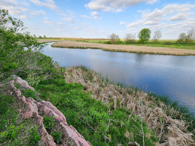
Prairie wetland and more granite.
We both made the critical mistake of bringing summer sleeping bags. The night temps dipped into the 40s and even the blankets we purchased at the camp store couldn't help us. I spent the night shivering under my bag, blanket, and motorcycle jacket. No amount of layers, and I was wearing them all, would save us from this mistake.
Blue winged teal in the morning.
A tepee (tipi) on the bison range ready to receive guests.
We were up early the next morning for some hot breakfast and a hike that quickly warmed us. The bison were on the move, likely warming up as well. Although that's probably less of a problem under their fur coats.
Fire and bison.
Western.
More bikes, more bison.
Cacti at last! Found high up on the granite ridge.
Stone from this quarry was used in buildings throughout
Minnesota and the Dakotas.
Turkey vultures keep watch now.
Views from the southern parking lot are grand.
After picking up camp we rode up to Pipestone National Monument. I wasn't sure what to expect and was surprised by the quality of the exhibits and the hiking. Native American artifacts were respectfully on display and well documented. Tribal members were on hand working the stone and talking up visitors. Pipestone national Monument is an active site and limited to tribal use but, there are well marked hiking paths for all visitors.
Hiking in Pipestone.
More hiking.
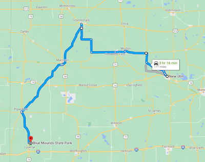
From Pipestone our plans got a little off. I had wanted to spend a night at Upper Sioux Agency State Park just outside of Granite Falls, still well into western Minnesota but we changed our plans. Dad wanted to ride home to eastern Wisconsin on Sunday so we aimed for New Ulm instead.
A highlight of the western roads is 23 from Pipestone to Marshall. It takes you through the ridges and valleys of the prairie coteau, an area of western range land with large, shallow gullies that descend from a massive plateau area. (the change in elevation is due to the weight of the glaciers.)
Unfortunately, due to my lack of sleep and desire to see the worlds oldest rock in Granite Falls, we continued north east to GF rather than heading west at Marshall. I had it in my head to ride the Minnesota River valley from GF to New Ulm but I was far too tired to keep track of the route. (we did find some fun roads around New Ulm) By the time we got to New Ulm I was too tired to eat so we got a hotel and called it for the day.
Warm beds and a shower worked wonders. The next day we walked over to the restaurant for breakfast and then down the road to Shell's Brewery. Being Sunday morning, it was just us and the peacocks.
From Mankato, we said our goodbyes and parted ways. I was heading back up 169, Dad took off east on 14.
The route to New Ulm got a little too ambitious.
Road closures along the Minnesota River didn't do us any favors either.
So, what did I learn about riding out west? Well, bring the correct sleeping bag and don't be afraid to book a hotel when needed. Exploring the park will push your departure time well into lunch, best to plan a half day to explore and ride in the afternoon. And find some county parks along the route to stop and stretch.
- Ride North
May 19th – 20th | 50s and cloudy, 40s
at night, then 60’s and sunny | 158 mi. and 177 mi.


